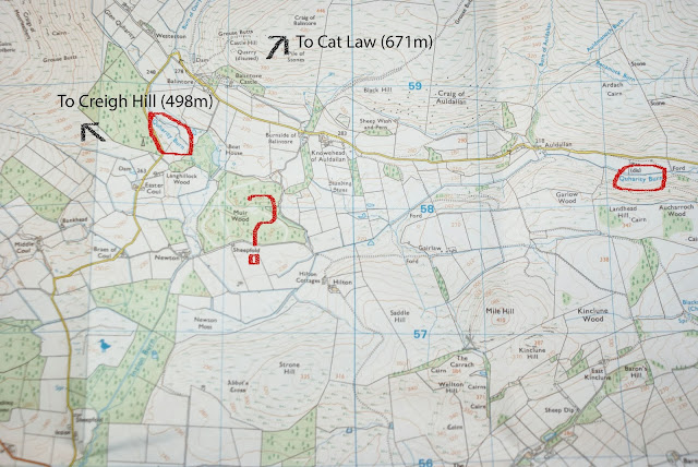
Some vital statistics
A little more poring over maps today building up an overall picture of the walk. Some of those vital statistics are as follows:
Length: Approx. 282 miles/454km. Perhaps a few miles longer on the ground - I used Mapometer to work it out. I reckon it will take me around 3 to 4 weeks. Overall I think this is about the right size of challenge - not on the scale of a Brown or Hewitt, but a bit more than say the average TGO Challenge route with a few more hills on the way.
Munros en route: 31.
Corbetts en route: 14
A lot of heathery peathagged lumps up to Dalwhinnie, then some characterful classics thereafter. Here they are in the order they'd be climbed on an anti-clockwise walk (Corbetts in italics; an asterisk means they're a short detour from the watershed, usually c.1km, and can be easily included in the route):
Mayar*
Tom Buidhe
Cairn of Claise
Glas Maol
The Cairnwell
Carn a'Gheoidh
Beinn Iutharn Mhor
Carn Bhac*
An Sgarsoch
Carn Ealar
Beinn Bhreac*
Leathad an Taobhain
A'Chaoirnich*
An Dun
Carn na Caim
A'Bhuidheanach Bheag
A'Mharconaich*
Geal-charn
The Fara
Beinn Bheoil
Ben Alder
Sgor Gaibhre
Carn Dearg
Meall a'Bhuiridh
Creise
Stob Ghabhar
Stob a'Choire Odhair
Meall Buidhe
Beinn a'Chreachain
Beinn Achaladair
Beinn Mhanach*
Beinn nam Fuaran
Beinn a'Chaisteal
Cam Chreag
Beinn Chaorach
Beinn Odhar
Beinn Chuirn
Ben Lui
Ben Oss
Beinn Dubhchraig
Cruach Ardrain
Stob Binnein
Meall an t-Seallaidh
Beinn Each
Stuc a' Chroin
Highest point: Stob Binnein (1165m)
Calories expended: 20,624 according to Mapometer. That's apparently around 73 Mars bars.
Length: Approx. 282 miles/454km. Perhaps a few miles longer on the ground - I used Mapometer to work it out. I reckon it will take me around 3 to 4 weeks. Overall I think this is about the right size of challenge - not on the scale of a Brown or Hewitt, but a bit more than say the average TGO Challenge route with a few more hills on the way.
Munros en route: 31.
Corbetts en route: 14
A lot of heathery peathagged lumps up to Dalwhinnie, then some characterful classics thereafter. Here they are in the order they'd be climbed on an anti-clockwise walk (Corbetts in italics; an asterisk means they're a short detour from the watershed, usually c.1km, and can be easily included in the route):
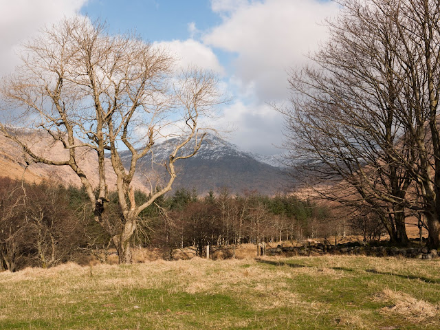
 |
| Beinn Chaorach, June 2012 |
Tom Buidhe
Cairn of Claise
Glas Maol
The Cairnwell
Carn a'Gheoidh
Beinn Iutharn Mhor
Carn Bhac*
An Sgarsoch
Carn Ealar
Beinn Bhreac*
Leathad an Taobhain
A'Chaoirnich*
An Dun
Carn na Caim
 |
| Carn Dearg, March 2012 |
A'Mharconaich*
Geal-charn
The Fara
Beinn Bheoil
Ben Alder
Sgor Gaibhre
Carn Dearg
Meall a'Bhuiridh
Creise
Stob Ghabhar
Stob a'Choire Odhair
Meall Buidhe
Beinn a'Chreachain
 |
| Ben More, Stob Binnein and Cruach Ardrain from Beinn Chaluim, June 2012 |
Beinn Mhanach*
Beinn nam Fuaran
Beinn a'Chaisteal
Cam Chreag
Beinn Chaorach
Beinn Odhar
Beinn Chuirn
Ben Lui
Ben Oss
Beinn Dubhchraig
Cruach Ardrain
Stob Binnein
Meall an t-Seallaidh
Beinn Each
Stuc a' Chroin
Highest point: Stob Binnein (1165m)
Calories expended: 20,624 according to Mapometer. That's apparently around 73 Mars bars.
 |
| Stuc a'Chroin and Ben Vorlich from Meall na Fearna, May 2012 |

Comments
Post a Comment