End to end across the high Ochils
The thing about Scotland is that even the flat bits are hilly, and the populated bits relatively wild. The fun doesn't begin and end in the the Highlands, and most people even in the central belt have hill days on the doorstep offering solitude and wildness way beyond what can be found in the south east of England. Whether the days are short or the weather bad or the Highlands snowed in or you're worried about your carbon footprint and don't fancy a long drive north, there are always options close to home - sometimes very challenging options in the depths of winter.
A series of little ranges are placed like steps across the central belt. Hamish Brown once walked from Abernethy on the Firth of Tay through to the Erskine Bridge on the Clyde, dropping gradually south west over the Ochils, Fintry Hills, Campsie Fells and Kilpatrick Hills. This trip could be extended at both ends - over the Sidlaws from Forfar to Perth in the east, and the Renfrew Heights from Inverclyde to Largs in the west.
Hamish Brown grew up at the foot of the 'couthy humps' of the Ochils and developed his love of the hills here. They were also fairly local to me, certainly the nearest substantial range of hills, rearing an impressive rampart above the carses of the Forth estuary and looking their full height and more. In winter conditions they can offer tough days - blizzards, difficult route finding, and sometimes huge accumulations of snow. They're extensive enough, and some of the slopes flanking escape routes down the glens to the south are steep enough, to make getting lost in winter potentially serious. For me, living near the Ochils meant I could be fighting through a winter blizzard at 3.30pm and sitting in the front room with the fire on and a mug of tea by 5.
Last week we had a few days at short notice in Scotland sorting things out for the move north in July. I had a day to myself but no time or transport to go far into the Highlands, so it had to be the Ochils, and a walk I've had my eye on for a while - crossing the hills from Sheriffmuir in the west to Glendevon in the east and exploring the less frequented uplands west of Ben Cleuch, highest and mid point of the range. A good 16 mile leg-stretcher.
Dumyat first, under an hour from the Sheriffmuir road. What it lacks in height it makes up for in character - buttressed and craggy, a stark contrast to the rolling grasslands and bogs of the main massif.
It's a jacket on, jacket off sort of day - biting wind and hot sun. In the end I stick with a windshirt over a t-shirt. Dumyat seems a world apart, offering a lot of contrast for little effort.
Although most hill names here are corruptions of Scots Gaelic, Dumyat and the name of the range itself are much older, from the Old Welsh/Brittonic languages that predated Gaelic. Dumyat refers to the Miathi, a local tribe, with 'Dum' denoting a fort. Ochil is from uchel, meaning 'high'. The Ochils form the northern border of Clackmannanshire. This tiny county is a curiosity with its origins in the deep past. The Brittonic kingdom of Manau existed at least as far back as the Roman occupation and probably further. Alistair Moffat writes in The Faded Map: Lost Kingdoms of Scotland:
In no time I'm approaching the summit of Dumyat...
...and the fertile estuary flatlands and loops of the tidal Forth are laid out below, bright and fresh in the morning.
If the Ochils were in England, or if the Highlands didn't exist, they would be a hugely popular and protected national park. Instead they are eaten away by forestry and wind farms. The more the Highlands are protected, the argument goes, the more vulnerable unsung places like the Ochils become, because that development still has to happen somewhere. However it's in places like the Ochils and Campsies and Renfrew Heights, empty hilly tracts hard up against the towns and cities, that you get an immediate sense of how much we need wild places, from the fresh water collected in the Glendevon reservoirs destined for the taps of Fife, to the fresh air and psychic space and little adventures in easy reach of so many.
For me, the main reason to preserve wild places is that non-human things deserve places to live as much as humans do. Maybe we're doomed to look out for our own first and foremost. But our system exacerbates this, creates and confuses needs and wants, and shuts the non-human world out of the moral equation when deciding what's acceptable and what isn't. The price of progress is hidden at every turn, cause and effect is masked, until it starts to erupt into everyday life: crashing bird populations, loss of topsoil, decline of bees, wind farms in places we thought industrialisation could never reach, oceans of plastic, deadly air pollution in the cities. Where is it all heading, and who really benefits? This version of progress starts to look like cannibalism on a global scale. Maybe protecting nature comes back to self-interest after all.
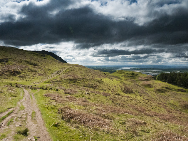
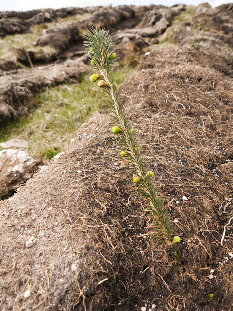
I was thinking these gloomy (and unoriginal) thoughts as I climbed onto the main spine of the Ochils and took in the view across Strathallan, from the hills newly gouged and planted mostly with commercial conifers, past the Beauly-Denny pylons to the Braes of Doune wind farm on the edge of the Highlands. Skylarks still sang above the wrecked hillside, maybe not for much longer. Squeezed out for office paper.
Beyond the scars of new forestry I was into unfrequented boggy moors. Beyond Blairdenon Hill was an extensive area of mixed heather, grass and peat hags, home to a small population of red grouse - a wild and unmanaged population; these aren't grouse moors. Everywhere the endless uplifting songs of skylarks, rising up until just a dot in the sky, slowly returning to earth, over and over.
Tramping through the bogs, a gear failure became apparent. My North Face Hedgehog Gore-tex trail shoes were clearly holed below the waterline.
Closer inspection revealed the outer fabric coming away from the outsoles in a couple of places on both shoes, with the damaged Gore-tex liner showing underneath. The shoes are now effectively useless after less than 100 miles. A lesson learned the hard way: don't mess with Gore-tex trail shoes. Luckily I've got a pair of the renowned Inov-8 Terroc 330s at home.
Ploughing on to Ben Cleuch for lunch...
...I meet a guy on the summit wearing a spanking new pair of Inov-8s and share my tale of trail shoe woe before hunkering down out of the wind for lunch, socks, shoes and insoles spread around me to dry a little in the wind and sun.
Ben Cleuch is the halfway point on the map, but on the ground it's quicker and easier going from now on - less boggy, mostly downhill, on very familiar terrain. Burnfoot wind farm flails on the left, Green Knowes is ahead, the turbines lining the ridge on the far side of Glen Devon. I cross Andrew Gannell Hill - a uniquely crazy anglicisation of the Gaelic an sruth gainmeail ('sandy stream') according to the SMT's Scottish Hill & Mountain Names book - and on to Tarmangie, torr na mainge, or 'hill of the fawn'.
From here I take the long ridge to Innerdownie which separates two lovely little glens which are being transformed by the Woodland Trust - Glen Sherup and Glen Quey. Curious wheatears troop along the tumbledown drystane dyke that tops the ridge.
There's a spot at the lowest point of the ridge between Tarmangie and Innerdownie which I've often felt has an atmosphere. On the left is the upper treeline of the Forestry Commission conifer plantation that covers the east side of Glen Sherup. An isolated group of conifers conceals a vigorous spring that sends its waters down towards Glen Sherup. The wind is roaring through the trees like a waterfall as I pass by. Soon I'm on Innerdownie looking back the way I came.
It's been a joy of a walk, so much hill country travelled with ease, but it ends here. I wind down into the forest, past Glensherup reservoir...
...past shady verges full of red campion...
...and out to the valley floor and the car park by a burn fringed by marsh marigolds. My dad pulls in after five minutes. Half an hour later I'm back home, feet up with a beer, nursing sunburned legs, children climbing all over me.
A series of little ranges are placed like steps across the central belt. Hamish Brown once walked from Abernethy on the Firth of Tay through to the Erskine Bridge on the Clyde, dropping gradually south west over the Ochils, Fintry Hills, Campsie Fells and Kilpatrick Hills. This trip could be extended at both ends - over the Sidlaws from Forfar to Perth in the east, and the Renfrew Heights from Inverclyde to Largs in the west.
Hamish Brown grew up at the foot of the 'couthy humps' of the Ochils and developed his love of the hills here. They were also fairly local to me, certainly the nearest substantial range of hills, rearing an impressive rampart above the carses of the Forth estuary and looking their full height and more. In winter conditions they can offer tough days - blizzards, difficult route finding, and sometimes huge accumulations of snow. They're extensive enough, and some of the slopes flanking escape routes down the glens to the south are steep enough, to make getting lost in winter potentially serious. For me, living near the Ochils meant I could be fighting through a winter blizzard at 3.30pm and sitting in the front room with the fire on and a mug of tea by 5.
Last week we had a few days at short notice in Scotland sorting things out for the move north in July. I had a day to myself but no time or transport to go far into the Highlands, so it had to be the Ochils, and a walk I've had my eye on for a while - crossing the hills from Sheriffmuir in the west to Glendevon in the east and exploring the less frequented uplands west of Ben Cleuch, highest and mid point of the range. A good 16 mile leg-stretcher.
Dumyat first, under an hour from the Sheriffmuir road. What it lacks in height it makes up for in character - buttressed and craggy, a stark contrast to the rolling grasslands and bogs of the main massif.
It's a jacket on, jacket off sort of day - biting wind and hot sun. In the end I stick with a windshirt over a t-shirt. Dumyat seems a world apart, offering a lot of contrast for little effort.
Although most hill names here are corruptions of Scots Gaelic, Dumyat and the name of the range itself are much older, from the Old Welsh/Brittonic languages that predated Gaelic. Dumyat refers to the Miathi, a local tribe, with 'Dum' denoting a fort. Ochil is from uchel, meaning 'high'. The Ochils form the northern border of Clackmannanshire. This tiny county is a curiosity with its origins in the deep past. The Brittonic kingdom of Manau existed at least as far back as the Roman occupation and probably further. Alistair Moffat writes in The Faded Map: Lost Kingdoms of Scotland:
Perhaps the most amazing survival is the kingdom of Manau. Its heartland lasted until 1974 in the shape of Clackmannanshire, Scotland's smallest county. Ignored by all but antiquaries, its talisman stands next to the old county buildings in Clackmannan. Clach na Manau is the Gaelic version of the origin name for the Stone of Manau, the core of the ancient kingdom and the derivation of Clackmannan.Clackmannanshire was restored in a subsequent local government re-organisation in 1996.
In no time I'm approaching the summit of Dumyat...
...and the fertile estuary flatlands and loops of the tidal Forth are laid out below, bright and fresh in the morning.
If the Ochils were in England, or if the Highlands didn't exist, they would be a hugely popular and protected national park. Instead they are eaten away by forestry and wind farms. The more the Highlands are protected, the argument goes, the more vulnerable unsung places like the Ochils become, because that development still has to happen somewhere. However it's in places like the Ochils and Campsies and Renfrew Heights, empty hilly tracts hard up against the towns and cities, that you get an immediate sense of how much we need wild places, from the fresh water collected in the Glendevon reservoirs destined for the taps of Fife, to the fresh air and psychic space and little adventures in easy reach of so many.
For me, the main reason to preserve wild places is that non-human things deserve places to live as much as humans do. Maybe we're doomed to look out for our own first and foremost. But our system exacerbates this, creates and confuses needs and wants, and shuts the non-human world out of the moral equation when deciding what's acceptable and what isn't. The price of progress is hidden at every turn, cause and effect is masked, until it starts to erupt into everyday life: crashing bird populations, loss of topsoil, decline of bees, wind farms in places we thought industrialisation could never reach, oceans of plastic, deadly air pollution in the cities. Where is it all heading, and who really benefits? This version of progress starts to look like cannibalism on a global scale. Maybe protecting nature comes back to self-interest after all.
I was thinking these gloomy (and unoriginal) thoughts as I climbed onto the main spine of the Ochils and took in the view across Strathallan, from the hills newly gouged and planted mostly with commercial conifers, past the Beauly-Denny pylons to the Braes of Doune wind farm on the edge of the Highlands. Skylarks still sang above the wrecked hillside, maybe not for much longer. Squeezed out for office paper.
Beyond the scars of new forestry I was into unfrequented boggy moors. Beyond Blairdenon Hill was an extensive area of mixed heather, grass and peat hags, home to a small population of red grouse - a wild and unmanaged population; these aren't grouse moors. Everywhere the endless uplifting songs of skylarks, rising up until just a dot in the sky, slowly returning to earth, over and over.
Tramping through the bogs, a gear failure became apparent. My North Face Hedgehog Gore-tex trail shoes were clearly holed below the waterline.
Closer inspection revealed the outer fabric coming away from the outsoles in a couple of places on both shoes, with the damaged Gore-tex liner showing underneath. The shoes are now effectively useless after less than 100 miles. A lesson learned the hard way: don't mess with Gore-tex trail shoes. Luckily I've got a pair of the renowned Inov-8 Terroc 330s at home.
Ploughing on to Ben Cleuch for lunch...
...I meet a guy on the summit wearing a spanking new pair of Inov-8s and share my tale of trail shoe woe before hunkering down out of the wind for lunch, socks, shoes and insoles spread around me to dry a little in the wind and sun.
Ben Cleuch is the halfway point on the map, but on the ground it's quicker and easier going from now on - less boggy, mostly downhill, on very familiar terrain. Burnfoot wind farm flails on the left, Green Knowes is ahead, the turbines lining the ridge on the far side of Glen Devon. I cross Andrew Gannell Hill - a uniquely crazy anglicisation of the Gaelic an sruth gainmeail ('sandy stream') according to the SMT's Scottish Hill & Mountain Names book - and on to Tarmangie, torr na mainge, or 'hill of the fawn'.
From here I take the long ridge to Innerdownie which separates two lovely little glens which are being transformed by the Woodland Trust - Glen Sherup and Glen Quey. Curious wheatears troop along the tumbledown drystane dyke that tops the ridge.
 |
| Glenquey Reservoir |
There's a spot at the lowest point of the ridge between Tarmangie and Innerdownie which I've often felt has an atmosphere. On the left is the upper treeline of the Forestry Commission conifer plantation that covers the east side of Glen Sherup. An isolated group of conifers conceals a vigorous spring that sends its waters down towards Glen Sherup. The wind is roaring through the trees like a waterfall as I pass by. Soon I'm on Innerdownie looking back the way I came.
It's been a joy of a walk, so much hill country travelled with ease, but it ends here. I wind down into the forest, past Glensherup reservoir...
...past shady verges full of red campion...
...and out to the valley floor and the car park by a burn fringed by marsh marigolds. My dad pulls in after five minutes. Half an hour later I'm back home, feet up with a beer, nursing sunburned legs, children climbing all over me.


Comments
Post a Comment